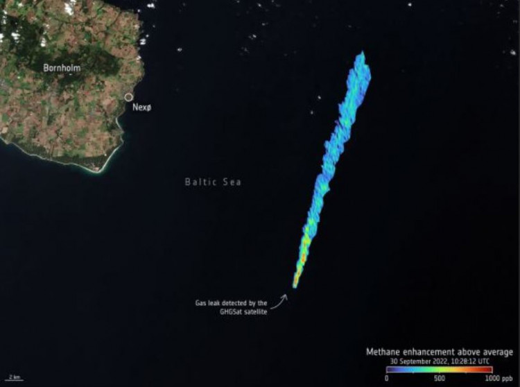
GHGSat, a private company that has active satellites monitoring methane emissions from space, has used its constellation of high-resolution satellites to measure the pipeline leak from the underwater Nord Stream 1 and 2 gas pipelines, which are located near Denmark and Sweden.
According to a press statement from the European Space Agency, GHGSat tasked its radar and microwave satellites with obtaining measurements at larger viewing angles and was able to target the area where the Sun's light reflected the most strongly off the sea surface - known as the 'glint spot.'
They discovered that on Sept. 30, the estimated emission rate, as determined by the initial methane concentration measurement, was 174,000 pounds per hour, making this the greatest methane leak ever identified by GHGSat from a single point-source.
Given that there are just four pipeline rupture spots and that this image was taken four days after the original breach, GHGSat deemed this rate to be incredibly high.
The company said in a news release that this amount of methane is equal to burning more than 90,000 kilos (2 million pounds) of coal in a period of one hour.
Both pipelines were constructed to carry natural gas from Russia to Germany via the Baltic Sea and are owned by Russia.
Officials have stated that the leaks, which were found on Sept. 26 and were caused by intentional sabotage more likely than not, were not accidents but rather planned action. Although there have been many accusations, the reasons for the harm are yet unknown.
Seismic activity was discovered in the Baltic Sea, and officials stated that while neither pipeline was delivering gas at the time of the blasts, it still contained compressed methane, which is the major component of natural gas.
The methane has now poured out, creating a large stream of bubbles on the sea surface that can be seen from several satellites in Earth orbit.
According to ESA, monitoring methane over water is exceedingly challenging since water absorbs the majority of sunlight in the shortwave infrared wavelengths utilized for methane remote sensing. This reduces the quantity of light reaching the sensor, making measuring methane concentrations over the sea at high latitudes extremely difficult.
The difficulty of making satellite observations of this occurrence was exacerbated by cloud cover.
Even though it is non-toxic and partially dissolves in water, methane ranks as the second most prevalent anthropogenic greenhouse gas in our atmosphere, which is what is causing climate change.
"The power of active microwave radar instruments is that they can monitor the ocean surface signatures of bubbling methane through clouds over a wide swath and at a high spatial resolution overcoming one of the major limitations to optical instruments," ESA's Scientist for Ocean and Ice, Craig Donlon, said.
"This allows for a more complete picture of the disaster and its associated event-timing to be established."