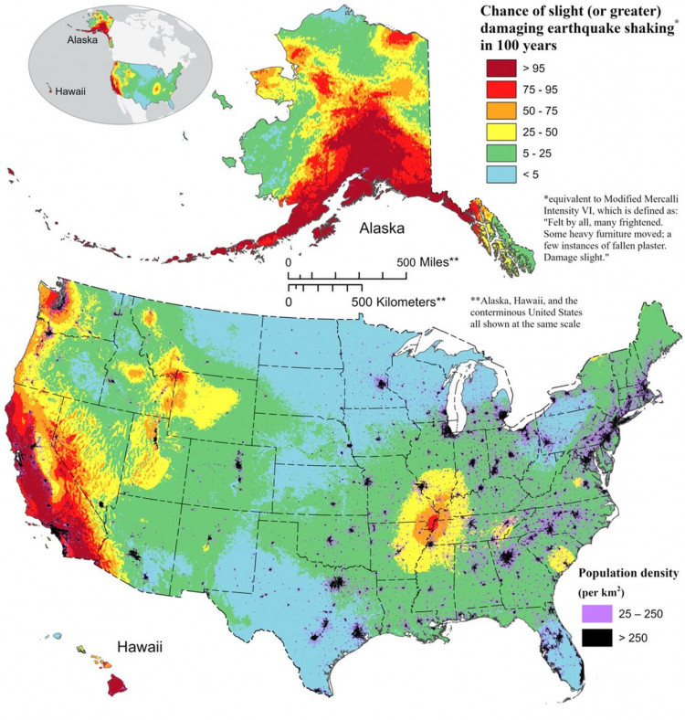
A recent revelation by the U.S. Geological Survey (USGS) has brought to light a startling reality: nearly three-quarters of the United States is at risk of experiencing damaging earthquakes. This significant discovery, derived from a sophisticated model and depicted in a newly released color-coded earthquake map, indicates that vast portions of the country, including several major cities, lie within high-risk seismic zones.
The new model, which was published on December 29 in the journal Earthquake Spectra, represents a comprehensive update to the understanding of earthquake risks in the United States. Not only does it encompass the traditionally recognized seismic hotspots of California, Oregon, and Washington, but it also extends to cities less commonly associated with earthquake risks, such as Salt Lake City and Memphis. This expansive coverage has led to the startling realization that 37 U.S. states have witnessed earthquakes with magnitudes greater than 5 in the past two centuries.
Significantly, the updated model underscores an increased probability of damaging earthquakes along the central and northeastern Atlantic coastal corridor. This includes densely populated areas like Washington D.C., Philadelphia, New York, and Boston. Mark Petersen, a geophysicist at the USGS and the lead author of the study, emphasized the importance of these findings. "The update includes more faults, better-characterized land surfaces, and computational advancements in modeling that provide the most detailed view ever of the earthquake risks we face," he stated.
The process of earthquake generation involves tectonic plates getting locked as they move over Earth's mantle. The built-up forces eventually cause a sudden shift, resulting in a rupture that releases energy through seismic waves, shaking the ground violently. While efforts to predict major earthquakes have been ongoing for decades, a precise map of the Earth's subterranean crust has remained elusive. Consequently, geophysicists have relied on historical data of past earthquakes to create risk maps, indicating the locations of potential seismic activity.
The new USGS map, which is the first National Seismic Hazard Model to cover all 50 states, is a collaborative effort involving federal, state, and local officials. A notable update in the model is the upgraded strength of earthquakes in Hawaii, attributed to increased volcanic activity in recent years.
The implications of these findings are profound, particularly for public safety and infrastructure planning. "This was a massive, multi-year collaborative effort between federal, state and local governments and the private sector," Petersen remarked. "The new seismic hazard model represents a touchstone achievement for enhancing public safety."
With this updated model, geologists and engineers can now better prepare for the potential threats posed to the nation's infrastructure and millions of Americans. As the USGS continues to refine its seismic models, the importance of comprehensive emergency preparedness and infrastructure resilience becomes increasingly clear in the face of these widespread earthquake risks.