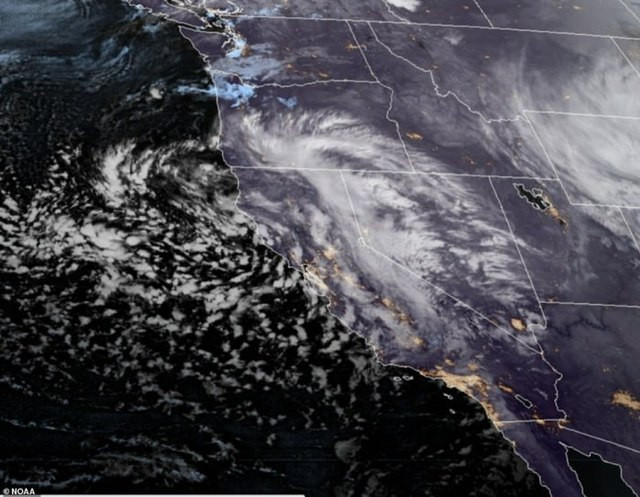
As California begins to recover from the impacts of a potent Pineapple Express storm, the state is bracing for a new challenge: an atmospheric river storm that promises a multiday siege of heavy rainfall, flash flooding, and heightened risks of mudslides and landslides, according to Fox Weather. This latest atmospheric disturbance, which commenced over the weekend, is tapping into a vast stream of tropical moisture originating from Hawaii, dousing various regions of California with significant precipitation.
In anticipation of the storm's severe impacts, officials in Santa Barbara County, situated northwest of Los Angeles, preemptively issued evacuation warnings on Saturday, urging residents in vulnerable areas to either evacuate or be prepared for potential isolation due to road damage and flooding. "Be prepared to sustain yourself and your household for multiple days if you choose not to evacuate," officials cautioned, highlighting the seriousness of the impending storm.
The threat of landslides became a stark reality in Klamath, near the Oregon border, where a hillside collapsed onto California's U.S. Highway 101, a chilling testament to the relentless rainfall's capacity to destabilize terrain. Fortunately, no injuries were reported in the incident.
To accommodate residents seeking refuge from the storm's wrath, emergency shelters were established in Santa Cruz County, operational on a first-come, first-serve basis and set to remain open until Wednesday, providing a temporary haven for those affected.
The atmospheric river storm that took hold on Sunday is expected to be particularly impactful due to its prolonged nature. "It's a similar setup to what we had with the last atmospheric river. Not as much moisture, but the ground is saturated, and that's where the impacts will happen," explained FOX Weather Meteorologist Craig Herrera, underscoring the compounded risk due to already saturated ground conditions.
The National Oceanic and Atmospheric Administration's (NOAA) Weather Prediction Center (WPC) has highlighted a Level 3/4 risk of flooding for the Santa Ynez range in Santa Barbara County, extending northward to include the Santa Lucia range in San Luis Obispo and Monterey counties. This designation points to a significant threat of flooding, with most of Northern and Central California, including cities such as Eureka, Fort Bragg, and San Francisco, under a Level 2/4 risk.
Rainfall predictions suggest that most areas will receive between 2 and 3 inches of rain over the coming days, with certain coastal regions from Fort Bragg to Los Angeles potentially experiencing 3-5 inches. Locally higher amounts ranging from 5-8 inches are also within the realm of possibility, particularly in the lower elevations of the Sierra Nevada mountain range before precipitation transitions to snow at higher elevations.
Atmospheric rivers, characterized by their extensive bands of water vapor stretching thousands of miles from the tropics, are pivotal in shaping the West Coast's precipitation patterns. These meteorological phenomena can account for up to 50% of the annual precipitation in some regions, underscoring their significance in the hydrological cycle, despite their potential for causing severe weather events.
As California grapples with this latest atmospheric river event, the state remains on high alert, with communities and emergency services mobilizing to mitigate the impacts of this formidable weather system.


