A potent winter storm has swept across Colorado, leaving tens of thousands in the metro Denver area without power and setting the stage for an unprecedented weather event that could potentially spark tornadoes over the weekend. Xcel Energy reported over 700 outages, affecting approximately 51,532 customers from Boulder to Castle Rock, with Littleton, Denver, Lakewood, and Golden among the hardest hit. The utility company has been actively addressing the outages and encourages customers to utilize their outage map and various reporting tools for updates and notifications.
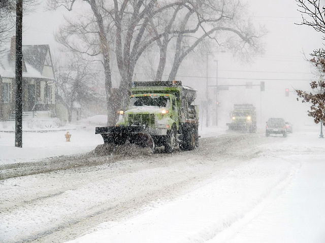
The storm, which commenced overnight on Wednesday, has blanketed the region with substantial snowfall, exceeding two feet in some Front Range foothills and delivering up to 10 inches across metro Denver. This severe weather has significantly impacted traffic flow, led to flight disruptions, and caused school cancellations and delays. The National Weather Service in Boulder anticipates the storm will continue, potentially depositing more than a foot of snow across Denver and upwards of four feet in certain mountainous and foothill areas by Friday morning.
However, the aftermath of this winter onslaught is not the only concern. Meteorologists warn of a brewing clash between polar winds driven by the storm and warm air surging from the Gulf of Mexico. This conflict of air masses, steered by an erratic jet stream, creates prime conditions for severe storms and possibly tornadoes, deviating from their typical trajectory in the so-called 'tornado alley.' Jim Dale, a meteorologist with British Weather Services, highlighted the significant atmospheric variance as a catalyst for potential large-scale storms and tornado threats extending beyond the usual regions of Kansas, Arkansas, Alabama, and Tennessee.
Dubbed Winter Storm Qadir, this weather phenomenon marks the most severe snowstorm the area has witnessed in three years, prompting emergency services to advise against non-essential travel. The juxtaposition of heavy snowfall in the north with early summer-like conditions in southwestern states underscores the stark weather contrasts sweeping the nation.
As St. Patrick's Day weekend approaches, a dramatic shift in the jet stream configuration is expected, bringing colder weather to the eastern half of the country while western Canada experiences a northward diversion. Jonathan Erdman, a meteorologist with the Weather Channel, elucidates this impending change, noting its impact on the weather pattern that has prevailed since late February.
This weather pattern inversion is anticipated to usher in drier conditions for most of the West, courtesy of a high-pressure system, with the exception of the southern Rockies and Southwest, where trapped low-pressure systems could yield rain and mountain snow. As the jet stream undergoes a significant transformation, the final weeks of March are likely to remain unseasonably cold, challenging residents and emergency services alike as they navigate the tumultuous and unpredictable weather landscape.
The Denver Post and CBS Colorado also contributed to this report.


