Two rapidly advancing wildfires have forced the evacuation of thousands of residents from the southern New Mexico village of Ruidoso. The fires, described as converging "like a pair of tongs," have created a dire situation, with local authorities issuing urgent evacuation orders and emergency services scrambling to respond.
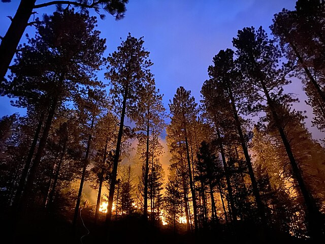
On Monday evening, a dense wall of smoke loomed over Ruidoso as residents evacuated in a lengthy line of cars. The South Fork Fire, which ignited that morning on Mescalero Apache tribal land, had already expanded to over 5,000 acres by nightfall, according to George Ducker, a spokesperson for the New Mexico Forestry Division. Meanwhile, the Salt Fire, another blaze burning on tribal land south of Ruidoso, had consumed 2,000 acres.
"The duration of this heat wave is notable and potentially the longest experienced in decades for some locations," the Weather Prediction Center stated.
The fires' rapid growth has been exacerbated by extremely dry air and high temperatures, conditions that have led the Storm Prediction Center to issue an elevated fire risk warning for most of New Mexico. The South Fork Fire is currently zero percent contained, and the threat to multiple structures remains high, with some already reported lost.
Evacuation orders cover both the village of Ruidoso, home to about 8,000 permanent residents, and parts of the Mescalero Apache Indian Reservation, including Snow Springs, Fence Canyon, and other areas. State Police in southern New Mexico are also grappling with phone outages, potentially hindering their ability to respond to 911 calls.
The fires are part of a broader crisis, with multiple blazes across the western United States. A 15,000-acre fire in Los Angeles County and another in Northern California's Sonoma County, which has burned over 1,000 acres, are among the most significant.
Ruidoso, a village known for its recreational appeal with winding trails and vast parks, finds itself in an unprecedented emergency. Rebecca Dennis, a vacationer from Oklahoma, recounted the chaotic evacuation. "I can't imagine the chaos had we not been prepared. I truly feel awful for those residents & everyone. But it was ... horrible to see the fires all around us," she wrote on Facebook.
Highway closures have complicated the evacuation efforts, with both Highway 48 and Highway 70 at Apache Summit shut down due to the South Fork Fire. The only evacuation route remaining is Sudderth to Highway 70, leading out to Roswell, about 70 miles east of Ruidoso. Roswell has mobilized to accommodate evacuees, clearing hospital space and setting up emergency shelters for people and livestock. Eastern New Mexico University has opened a shelter, and the Eastern New Mexico State Fairgrounds is available for evacuees with RVs or large animals.
Public Service Company of New Mexico (PNM) has shut off power to portions of Ruidoso at the request of first responders, affecting nearly 800 homes and businesses. "Public safety is a top priority and we do not take this decision lightly but are doing all we can to work in lockstep with our first responders who are helping the communities who are impacted," PNM stated on Facebook.
The explosive growth of the wildfires has been fueled by climate change-driven conditions, with scientists warning that such destructive events will become more frequent. Lincoln County, where Ruidoso is located, is experiencing severe drought, contributing to the fires' intensity.
The South Fork Fire began on the Mescalero Apache Reservation, where the tribal president has declared a state of emergency. The Salt Fire is also burning on tribal and U.S. Forest Service land within areas surrounding Ruidoso. Both fires are contributing to severe air quality issues, with an air quality alert issued for very unhealthy air due to smoke.
In light of these conditions, the Federal Emergency Management Agency (FEMA) had designated Ruidoso as a high-risk area for wildfires as early as 2000, citing the dense forests surrounding the village that could serve as fuel for catastrophic fires.


