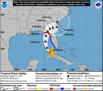
Tropical Storm Debby, the fourth named storm of the 2024 Atlantic hurricane season, has formed in the Gulf of Mexico and is expected to intensify into a hurricane before making landfall in Florida. As of the latest update from the National Hurricane Center, Debby has sustained winds of 40 mph and is located approximately 270 miles south of Tampa, Florida. The storm is projected to reach Category 1 hurricane strength with winds of 75 mph by the time it hits Florida's Big Bend region on Monday morning.
The United States Air Force Reserve and the National Oceanic and Atmospheric Administration's Hurricane Hunters are currently en route to monitor Debby's progression. Hurricane warnings are in effect for the Florida Gulf Coast from the Suwannee River to the Ochlockonee River, encompassing the entire Big Bend region. A hurricane watch is also in place from Yankeetown northward to Indian Pass on the Florida Panhandle.
"The system is likely to be at or near hurricane strength when it reaches the Florida Gulf Coast," stated the National Hurricane Center. The storm's projected path through the Gulf of Mexico, with its record-warm water temperatures, is expected to fuel its intensification.
Florida Governor Ron DeSantis has declared a state of emergency for 54 of the state's 67 counties in preparation for Debby's impact. "Floridians are encouraged to monitor weather conditions, listen to all orders from local officials, create disaster preparedness plans, and stock disaster supply kits with food, water, and other necessities for their households," the governor's office announced.
Local governments have issued various advisories and evacuation orders. Citrus, Levy, and Dixie counties have mandated evacuations in certain low-lying areas and for residents living in manufactured homes or RVs. Voluntary evacuation notices have also been issued in Pasco and Taylor Counties. Additionally, sandbag distribution began on Friday in several communities within the Orlando and Tampa metro areas, as well as multiple counties in the Panhandle.
Debby's formation follows a series of destructive storms this season, including Tropical Storms Alberto and Chris, and Hurricane Beryl. The storm is expected to bring significant rainfall, with projections indicating up to 18 inches in some areas. "Heavy rainfall will likely result in locally considerable flash and urban flooding across portions of Florida and the coastal areas of the Southeast this weekend through Thursday morning," the National Hurricane Center warned.
The atmospheric components that steer storms are predicted to break down, causing Debby to slow significantly after landfall. This deceleration could result in extensive rainfall and increased flooding risks in northern Florida and southern Georgia. "After landfall, weakening steering currents should cause the cyclone to slow down while it moves northeastward or eastward over parts of northern Florida and Georgia," the National Hurricane Center reported.
The potential for "life-threatening" storm surges is another major concern. Forecasts indicate up to 5 feet of storm surge in parts of the Big Bend and up to 4 feet from Bonita Beach through Tampa Bay. Regardless of its exact strength at landfall, torrential rainfall is anticipated to be the most significant impact, exacerbating the flood threat.
As Debby approaches, Florida and neighboring states are taking precautions. Georgia Governor Brian Kemp has also declared a state of emergency ahead of Debby's possible impacts. "As the state prepares for a major storm system early this coming week, we urge all Georgians to take precautions to keep their families and property safe," Kemp stated.
The storm's slow movement after landfall could lead to heavy rain accumulation along the Georgia-Carolina coastline. The Weather Prediction Center has increased the flood risk level to 3 out of 4 for coastal Georgia and South Carolina, including cities like Savannah and Charleston, for Monday into Tuesday.
The intensity and path of Debby highlight the increased risk of severe weather events fueled by climate change. Warmer ocean temperatures and slower-moving storms, both consequences of global warming, contribute to higher rainfall totals and more significant flooding. A 2022 study published in Nature Communications found that climate change increased hourly rainfall rates in tropical storms by 5 to 10% and in hurricanes by 8 to 11%.
Residents in the storm's path are urged to take immediate action to protect life and property. "This is a life-threatening situation," the National Hurricane Center emphasized. "Persons located within these areas should take all necessary actions to protect life and property from rising water and the potential for other dangerous conditions."


