Amid a summer marked by relentless heat waves and wildfires across the United States, an unexpected weather twist unfolded this past weekend in California, with parts of the Sierra Nevada Mountains receiving a dusting of snow. The unusual August snowfall, coupled with torrential rains in some areas, provided a brief but striking contrast to the scorching temperatures that have gripped much of the nation.
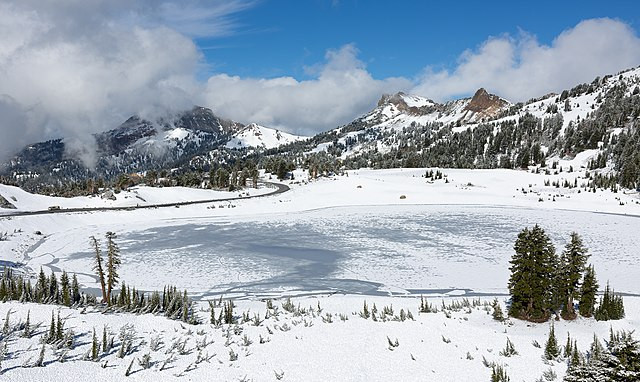
On Saturday, light snow was reported in several locations, including Lake Tahoe, Palisades Tahoe, and Lassen Volcanic National Park. According to the National Weather Service (NWS), the snow accumulation ranged from 0.03 inches in the Tahoe National Forest to 0.15 inches north of Stanislaus National Forest. Although the snow quickly began to melt, it created a temporary winter wonderland, providing a stark contrast to the sweltering heat in other parts of the country.
The snowfall was attributed to an unusually cold weather system that originated in the Gulf of Alaska. As it moved southward along the West Coast, the system brought unseasonably cold temperatures and precipitation to California and the Pacific Northwest. The NWS reported that temperatures in the affected areas dropped 15 to 20 degrees below normal, with Sunday morning lows expected to be in the low 30s. A frost advisory was issued for regions east of Reno, Nevada, warning residents of potential "hard freezes" that could damage crops and vegetation.
The rare summer snowstorm also had a significant impact on transportation and events in the region. In northern California, portions of Highway 89 through Lassen Volcanic National Park were temporarily closed due to the snowfall. Meanwhile, in northern Nevada, heavy rains disrupted preparations for the annual Burning Man festival, leading organizers to close the event's main gate on Saturday morning. Although the gate was reopened later in the day, the rain added to the challenges faced by attendees, echoing last year's festival, which was marred by similar weather disruptions.
The snowfall was also recorded at Palisades Tahoe, a popular ski resort in Olympic Valley, California. The resort shared images of the snow on social media, expressing surprise at the early arrival of winter-like conditions. "It's a cool and blustery August day here at Palisades Tahoe, as a storm that could bring our first snowfall of the season moves in this afternoon!" the resort posted.
The unexpected snow event underscored the extreme weather patterns that have characterized this summer. While California experienced a taste of winter, much of the rest of the country continued to endure oppressive heat. The NWS reported that Medicine Lodge, Kansas, recorded the highest temperature in the contiguous United States on Saturday, with a scorching 115 degrees. In Texas, Lubbock set a new record high of 104 degrees for the fourth consecutive day.
The heat wave, described by the NWS as "relentless," has affected millions of people across the Midwest, with temperatures soaring 10 degrees or more above normal in many areas. Heat alerts were issued for 23 million people from New Mexico to Minnesota. However, relief is on the horizon, as the same low-pressure system that brought snow to California is expected to push the heat wave out of the Midwest and bring cooler temperatures early this week.
Despite the temporary break in the heat, the NWS warned of continued fire danger in California due to gusty winds associated with the cold front. A flash flood watch was also issued for the burn scar of the Park Fire, California's largest wildfire of the year. The fire, which erupted in late July near Chico and scorched over 671 square miles, has been largely contained, but smoldering vegetation within its perimeter remains a concern.


