A powerful spring storm system is set to bring multiple days of severe weather to the central and eastern United States, with forecasters warning of strong tornadoes, damaging winds, large hail and life-threatening flooding affecting tens of millions from Texas to the Great Lakes through the end of the week.
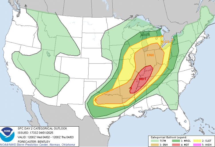
The National Weather Service Storm Prediction Center has issued a Level 4 of 5 risk for severe thunderstorms on Wednesday across parts of the Mississippi and Ohio Valleys, including cities such as St. Louis, Memphis, Indianapolis and Louisville. This alert level-rarely issued-indicates a high probability of widespread, damaging storms capable of producing long-track, EF2 or stronger tornadoes and destructive hail up to baseball size.
Tuesday marks the beginning of the outbreak, with storms expected to develop late afternoon in the Plains and rapidly intensify through the evening. Areas from northern Texas through Oklahoma and Kansas into Missouri are under threat for supercells capable of producing significant tornadoes, wind gusts over 70 mph and hail as large as golf balls.
"A multi-day severe weather outbreak is possible beginning Tuesday afternoon through overnight Wednesday," the Storm Prediction Center stated. A Level 3 of 5 threat has been issued for over 42 million people from Texas to the Great Lakes.
By Wednesday morning, remnants of overnight storms could linger in areas like Missouri, Kansas and Illinois before explosive redevelopment is expected later in the day across the Mississippi Valley. As warm, unstable air collides with a potent upper-level disturbance, conditions will be ripe for tornado-producing supercells and widespread damaging winds.
Cities including Chicago, Cincinnati, Dallas, and Nashville could be in the path of the most dangerous storms. The threat continues into Wednesday night with another potential round of severe storms sweeping across the lower Mississippi Valley and into northern Texas and southern Oklahoma.
The hazards extend beyond tornadoes. A slow-moving frontal boundary and persistent Gulf moisture are expected to trigger prolonged, heavy rainfall, setting the stage for what forecasters describe as a "generational" flooding event. The Weather Prediction Center has issued a Level 3 of 4 flood risk for parts of the Mississippi and Ohio valleys each day from Wednesday through Saturday.
"This is an increasingly significant setup," the WPC warned, noting "high impacts and life-threatening flash flooding spanning the course of several days."
Rainfall totals could reach 15 inches in localized areas from Arkansas through Kentucky by the weekend, with multiple rounds of storms repeatedly tracking over the same regions. The corridor where Arkansas, Missouri, Illinois, Kentucky and Tennessee meet is considered most vulnerable to extreme accumulations.
The National Weather Service office in Paducah, Kentucky, said, "If we get anywhere near these amounts, a historic flash flooding event is likely." The city averages about 14.5 inches of rain over the entire spring, but that amount could fall within just four days.
Many of the tornadoes could occur at night, compounding their danger. A 2022 study found that nighttime tornadoes are nearly twice as likely to be fatal, due to sleeping residents being caught off guard.
The upcoming system is the latest in a year that has already seen over 3,200 reports of tornadoes, hail, and damaging wind. In March, multiple outbreaks wreaked havoc across the Midwest and South. And just last week, parts of South Texas received more than six months' worth of rain in under 48 hours, prompting more than 100 water rescues and leaving four dead.


