A powerful spring storm system is sweeping across the central United States on Wednesday, threatening more than 70 million people with a rare combination of long-track EF-3 tornadoes, destructive hail, hurricane-force winds, and potentially historic flash flooding. The National Weather Service has placed much of the Lower Mississippi Valley, Mid-South, and Lower Ohio Valley under its highest "high risk" alert level for severe weather.
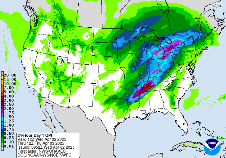
Meteorologists warn that the unfolding event could become a "once-in-a-generation" weather catastrophe, with the National Weather Service calling it a "multi-day catastrophic and potentially historic event." Flood watches already cover 33 million people from Texarkana to Detroit, including a "Particularly Dangerous Situation" designation-one of the rarest flood alerts issued.
The Storm Prediction Center has assigned a Level 5 out of 5 risk to parts of the Mississippi and Ohio River Valleys, a designation used sparingly and reserved for only the most severe threats. Cities most vulnerable include Memphis, Tennessee; Paducah, Kentucky; Little Rock, Arkansas; and Evansville, Indiana. Other major metropolitan areas facing damaging storms include Dallas, St. Louis, Indianapolis, Louisville, Chicago, and Cincinnati.
The greatest danger comes from multiple, long-track EF-3 or stronger tornadoes, capable of remaining on the ground for dozens of miles. Gusts up to 75 mph and hail as large as two inches are also forecast. Tornado watches are in effect across Missouri, Oklahoma, and Arkansas, with confirmed tornado sightings reported near Montrose, Missouri, Wednesday morning.
Rainfall totals through Sunday could exceed 10 to 15 inches in some locations, particularly in northeastern Arkansas, northwestern Tennessee, and western Kentucky. The intense rainfall is expected to arrive in multiple waves, with back-building storms dropping two to three inches per hour over the same areas for days. The weather service noted, "A heavy rainfall event of this magnitude falling within four days is an event that happens once in a generation to once in a lifetime."
This deluge is being fed by a highway of moisture streaming northward from the Gulf of Mexico and Caribbean, which is undergoing a marine heat wave. The high sea surface temperatures are contributing to excessive atmospheric moisture, raising the potential for record-setting precipitable water levels.
Climate scientists say these extreme precipitation and storm events are becoming more frequent due to warming global temperatures. A recent analysis from Climate Central found that heavy rainfall is increasing across all regions of the U.S., with local variations depending on geography and land use.
By Thursday, the same stalled storm front is expected to linger across the central U.S., extending the risk of severe weather and heavy rain through the weekend. Flash flooding could persist into Sunday, impacting 42 million people on Thursday, 22 million on Friday, 27 million on Saturday, and 12 million on Sunday.


