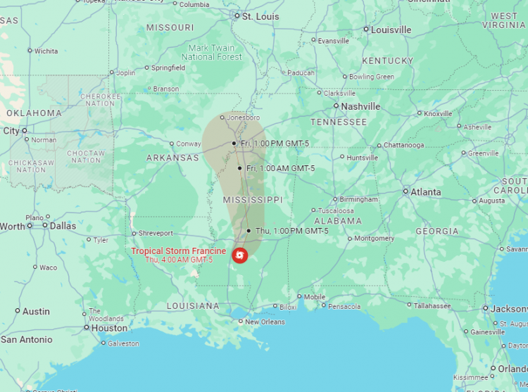
Tropical Storm Francine has left a trail of destruction across southern Louisiana, where it made landfall as a Category 2 hurricane before weakening to a tropical storm and now a tropical depression. The storm, which has caused widespread flooding and power outages, is the first hurricane to hit Louisiana since 2021 and marks the third U.S. landfalling hurricane this year-a statistic not seen since 2020.
Francine made its initial impact late Wednesday afternoon in Terrebonne Parish, bringing with it maximum sustained winds of 100 mph. By Thursday morning, the storm had lost much of its strength, with winds dropping to 45 mph as it moved northeast across Mississippi. Despite its weakening status, Francine continues to pose a significant threat, particularly with heavy rainfall and the potential for flash flooding in its path.
Flooding and Power Outages in Louisiana
In the New Orleans area, heavy rain-between 6 to 8 inches-fell overnight, leading to flash flooding that made roads impassable and threatened lives. A flash flood emergency was briefly issued on Wednesday night as water levels rose rapidly, straining the city's drainage systems. Of the 99 drainage pumps in New Orleans, 90 remained operational, though officials warned residents to stay off the streets due to severe flooding and dangerous conditions.
Jefferson Parish and St. James Parish were particularly hard hit, with officials in both areas urging residents to stay home. In Morgan City, residents were asked to remain indoors as floodwaters reached homes. The damage extended beyond flooding, with downed trees and power lines reported across several parishes, including Terrebonne, Lafourche, and St. Mary, leaving more than 380,000 utility customers without power.
Rescue Operations and Tornado Threats
The storm's impact prompted emergency response efforts across the region. In Lafourche Parish, deputies rescued 26 people trapped in their flooded homes on Wednesday night. The parish, like many others in the storm's path, remained without power, and a curfew was imposed until Thursday morning to ensure residents' safety.
As Francine moved inland, the National Hurricane Center issued tornado warnings for parts of Louisiana, Mississippi, Alabama, and the Florida Panhandle. The possibility of tornadoes adds to the already significant risk posed by the storm, which is also bringing dangerous surf and rip currents to the northern Gulf Coast.
Mississippi Braces for Impact
By early Thursday, Francine had reached Mississippi, where it continued to unleash heavy rain and strong winds. The National Hurricane Center downgraded the storm to a tropical depression, but forecasters warned that flash flooding remains a serious concern as the storm moves across the state. Up to 12 inches of rain could fall in some areas, exacerbating the risk of flooding.
Mississippi Governor Tate Reeves had already declared a state of emergency in anticipation of the storm's impact, with over 100,000 sandbags distributed across the state to help mitigate flood damage. Power outages have begun to affect central Mississippi, with the worst conditions expected to persist through the morning.
The Road to Recovery
As Francine continues its journey northeast, cooler temperatures and a shift in weather patterns are expected to help reduce its intensity. However, the damage left in the storm's wake will take time to address. In Louisiana, residents are still recovering from previous hurricanes, and Francine's arrival has added to the state's already heavy burden.
For many, the storm is a harsh reminder of the increasing frequency and intensity of hurricanes in the region, often linked to human-caused climate change. Terrebonne Parish resident Coy Verdin, who recently finished rebuilding his home after Hurricane Ida, expressed his frustration and determination: "As long as I can. It's getting rough, though," he said.
As the storm weakens and moves out of the Gulf region, attention will turn to recovery efforts and the ongoing challenges posed by an active hurricane season.


