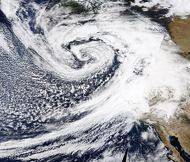
A powerful "bomb cyclone" storm has swept through the Pacific Northwest, unleashing destructive winds, heavy rainfall, and widespread power outages. As of Wednesday morning, over 600,000 homes and businesses in Washington were without electricity, with King County alone reporting more than 465,000 outages, according to USA TODAY's power outage tracker.
The storm, which intensified rapidly to earn its designation as a bomb cyclone, has battered the region since Tuesday. Wind gusts reached hurricane force in some areas, with speeds of 101 mph reported off Vancouver Island, 79 mph along the Oregon coast, and 77 mph at Mount Rainier in Washington, according to the National Weather Service (NWS). Falling trees have wreaked havoc, killing at least one person in Washington and leaving others injured.
In Lynnwood, Washington, a woman at a homeless encampment lost her life when a large tree fell on her Tuesday night, South County Fire confirmed. Meanwhile, in Seattle, a tree crushed a vehicle, temporarily trapping a person inside. The individual was later rescued and is reported to be in stable condition.
The storm has caused significant structural damage. In Issaquah, Washington, Wendy Harrington described a massive tree crashing into her home, shaking the entire structure. "It felt explosive, like there was a bomb going off," Harrington told KOMO-TV. "Everything was just very loud."
Authorities have issued widespread safety warnings. The Bellevue Fire Department urged residents to remain on the lowest floors of their homes and away from windows. "Trees are coming down all over the city & falling onto homes," the department posted on X, formerly Twitter. "Do not go outside if you can avoid it."
The storm has created additional challenges for emergency response teams and utilities, with internet outages and other technical difficulties disrupting storm updates and power restoration efforts. Fluctuating reports on outages reflect the widespread impact of the storm, which has also left over 8,000 without power in Oregon and more than 24,000 in California.
The extreme weather is part of a larger atmospheric river system bringing torrential rains to the Pacific Coast. The NWS Weather Prediction Center warned of excessive rainfall and the potential for flash flooding, particularly in Northern California. The San Francisco Bay Area, North Coast, and Sacramento Valley are bracing for up to eight inches of rain, with rockslides and debris flows anticipated.
In mountain regions, snowfall has compounded the dangers. A blizzard warning is in effect for the Cascades in Washington, including Mount Rainier National Park, where up to a foot of snow is expected along with wind gusts reaching 60 mph. The northern Sierra Nevada, above 3,500 feet, is forecasted to receive up to 15 inches of snow, accompanied by 75 mph winds, making travel hazardous or impossible.
The storm has disrupted daily life across the region. In Washington's Puget Sound area, rough seas and high winds forced the suspension of a ferry route between Port Townsend and Coupeville. Flood watches are also in effect for parts of southwestern Oregon through Friday evening.
Meteorologists are forecasting unsettled weather to continue into the weekend, with another front expected to arrive Friday. Thunderstorms are likely along the coast, exacerbating already challenging conditions. The NWS has urged residents to remain vigilant, avoid non-essential travel, and stay informed about changing weather conditions.


