A powerful storm battered Southern California this week, unleashing torrential rain, triggering mudslides, and leaving vehicles trapped in thick debris, but ultimately sparing wildfire-scorched areas from the worst-case scenario feared by officials.
The atmospheric river-fueled storm, which dumped more rain on Los Angeles in a single day than the city had received in the past nine months combined, caused localized flooding and significant debris flows. The National Weather Service reported record-breaking rainfall, with 2.8 inches recorded in downtown Los Angeles on Thursday, surpassing the previous record of 2.71 inches set in 1954.
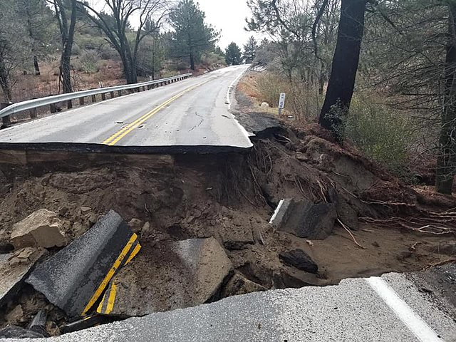
The storm's most intense period arrived late Thursday afternoon, prompting flash flood warnings across the region, including burn scar areas from past wildfires. The downpour caused rockslides and mudflows in Malibu Canyon and Sierra Madre, while a major debris flow in the Hollywood Hills left about 8 inches of mud on Mulholland Drive, rendering the road impassable.
"It's a resilient community," said Francisco Martinez, a resident of Sierra Madre, where roads were overwhelmed with mud. "The debris flow, the mud ... I've never seen it like this."
In Altadena, a neighborhood impacted by the Eaton Fire, crews worked through the night to free vehicles stuck in mud. Exhausted residents assisted one another, many still living with packed bags in case of additional evacuation orders.
One of the most dramatic incidents occurred in Malibu, where a debris flow swept a Los Angeles Fire Department member off a roadway and into the ocean. LAFD spokesperson Erik Scott said the firefighter sustained minor injuries. Nearby, a vehicle was seen partially submerged after being pushed off an embankment by floodwaters.
A Smart & Final grocery store in Azusa sustained structural damage when a section of its roof collapsed. "It was crazy," said Al Hernandez, who was inside the store at the time. "People were screaming and running, it was just madness." No injuries were reported.
The storm's rapid intensity led to rainfall rates of up to 1.2 inches per hour in some areas, surpassing the threshold that typically triggers flooding and debris flows. As a precaution, evacuation orders remained in effect for select residences near burn scars in the Los Angeles area through Friday afternoon. Officials warned that landslide risks persist even after rainfall ceases.
Daniel Swain, a climate scientist at the University of California, Los Angeles, noted that while Southern California remains in extreme or severe drought, the storm delivered more water than the landscape could absorb. "The area is desperate for rain, but this storm might bring too much too quickly," he said.
The same storm system is now moving eastward, bringing snow to the Rockies and raising flood risks from the Gulf Coast to the Northeast. The Weather Prediction Center has issued a flood warning for a 500-mile stretch from Arkansas to West Virginia, while the Storm Prediction Center warned of severe thunderstorms across Louisiana, Mississippi, Tennessee, and Alabama.


