Severe weather swept across the central United States on Monday, placing more than 45 million people under threat from powerful storms that forecasters warn could produce destructive tornadoes, giant hail, and damaging winds over multiple days.
The National Weather Service and Storm Prediction Center issued urgent warnings, predicting a "widespread, significant" threat for parts of the Midwest and Upper Midwest beginning late Monday afternoon into the evening. Meteorologist Chris Dolce of Weather.com stated that the atmosphere would be "very conducive for severe weather," with cold fronts and intense instability fostering dangerous conditions.
AccuWeather projected storms to organize along an advancing cold front stretching from eastern Dakotas, Minnesota, and western Wisconsin down through west-central Texas. Cities including Minneapolis, Des Moines, and Kansas City were identified as being in the direct path of the worst conditions.
"Tornadoes, some possibly strong (EF2 or greater damage), as well as large hail and damaging winds, are all possible threats," Dolce said. EF2 tornadoes carry wind speeds up to 135 mph and have historically caused widespread destruction.
Meteorologist Elizabeth Danco of AccuWeather warned that some tornadoes could be "long-lived," posing greater danger especially after dark when visibility is low. "This will pose a serious risk, particularly with those that develop after dark when they are more difficult to detect and prepare for," Danco said.
The threat is forecasted to intensify and shift eastward on Tuesday. Cities such as Dallas-Fort Worth, St. Louis, Indianapolis, Cincinnati, and Pittsburgh are bracing for severe thunderstorms, with risks including large hail, flash flooding, and additional tornadoes. "The potential for flash flooding from heavy rain is also in play," Dolce added.
By Wednesday, the storm system is expected to reach the Northeast and the lower Mississippi Valley, extending the severe threat further.
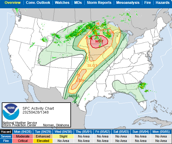
The ongoing outbreak could become one of the most significant of the year, forecasters said. The SPC, which had issued cautious alerts over the weekend, escalated its warnings Monday, labeling the event an "outbreak of severe weather" with "strong to intense tornadoes likely."
More than 47 million people across 16 states will remain under either marginal or slight risk levels by Tuesday into Wednesday, according to SPC outlooks.
In Illinois, the timing of severe weather was predicted for late Monday night into Tuesday morning, with a second round possible Tuesday afternoon and evening. The corridor along and south of Interstate 70 was particularly flagged for elevated tornado risk.
Illinois ranks among the most affected states this year. As of Sunday, it had reported 78 preliminary tornado incidents, second only to Mississippi's 96, according to preliminary data. Total severe weather reports in Illinois-including wind and hail events-stood at 391, ranking fourth nationally.
The 2025 tornado season has already produced 656 preliminary tornado reports nationwide, more than 236 above the average for this point in the year. Only 2011 saw a more active spring, with 970 tornado reports by late April, according to the National Weather Service.


