Mount Hallasan is dubbed as the highest mountain in South Korea. Situated on Jeju Island, the shield volcano attracts tourists from all over East Asia and the world. A lot of travelers want to try their luck and discover its summit, but park rangers warned it is only for "advanced" hikers.
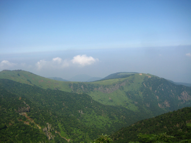
Mount Hallasan has a height of 1,950 meters (6,398 ft), making it the highest mountain in South Korea. It can be seen dominating the island of Jeju, while its summit is often covered by clouds. It has a large volcanic crater that goes over 400 meter (1,300 ft) that leaves the visitors guessing at its vastness.
South Korea's mainland can be very cold in winter, but Jeju Island's climate can be more tolerable. Hence, South China Morning Post's Paul Niel decided to visit Mount Hallasan to see and experience its majestic beauty.
Mount Hallasan is reportedly easily to hike on weekends. Hallasan National Park office's staff also assured that it is safe to go on a trail even if there is heavy rainfall. It will stay open with no crampons and other special gear needed to get there. However, because of the cold, the park ranger advised taking a jacket that will make you warm.
Hallasan National Park, which was named as a Unesco World Heritage Site in 2007, has four main trails, two of which lead to Mount Hallasan summit. The east trail or the Seongpanak trail is the most popular way to reach the top. The second one is the Gwaneumsa trail, which is from the north and the closer to Jeju City. Although the trail will be shorter here, it is also steeper.
Hikers will see a few harbung or the large rock statues which are believed to be gods of protection at the trail's entrance. There are also huge yellow signs at the trailhead to warn climbers that the hike is only for the experienced. There is also a required time that they should be at the Sangbank shelter, which is three-quarters of the way up, to have the permission to continue hiking.
The way to the Mount Hallasan summit is filled with signposts and distance markers to show the hikers' progress. There is also a monorail that ascents the route that is used for "resupplying the hut and evacuating hikers in trouble." Its steep steps, few ladders, and trail squeezed between rocky outcrops proved why it is only for advanced hikers.
Meanwhile, Jeju Weekly reported that Mount Hallasan's current shape had been formed by the volcanic activity that occurred between 20,000 and 37,000 years ago. The study, made by Dr. Lim Jae-soo from the Hallasan Research Institute and the Korean Geological Survey Institute, relates to the age of the Baekrokdam crater at the mountain's summit and the surrounding oreum.
Jae-soo's research is made to identify Baekrokdam geological formation period by measuring the age of Mount Hallasan's formation through its rocks by using the strategy called optically stimulated luminescence, which delivers 5-10 percent accuracy.
They found out Baekrokdam's western part was a steep lava dome formed by a large lava eruption 37,000 years ago, while its eastern part was formed through basaltic magma eruption 20,000 years ago that created the current crater. The rocks on its topsoil layer reportedly erupted 37,000 years ago.