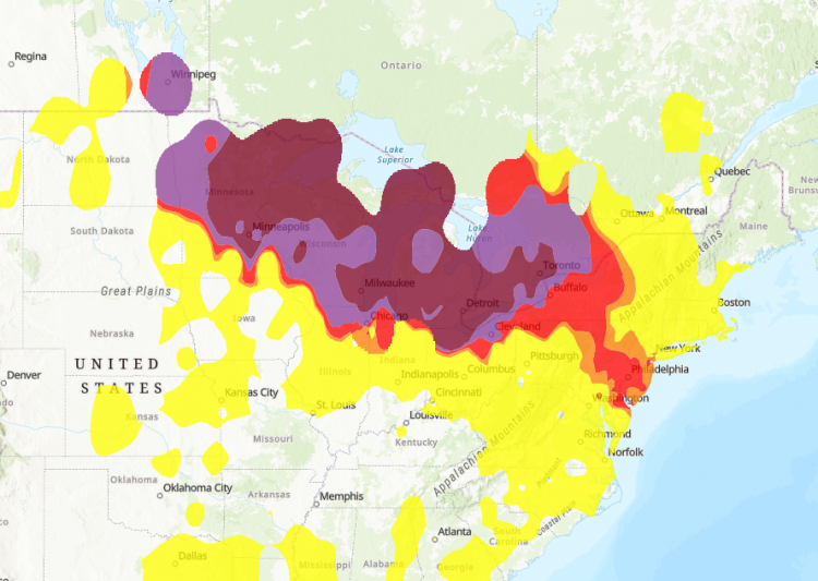
Canadian wildfire smoke has once again spread across the United States, degrading air quality from the Upper Midwest to the Northeast as a persistent heat dome traps pollution near the surface. The deteriorating conditions have prompted health warnings across major metropolitan areas including New York City, Minneapolis, Detroit, Scranton and Toronto, where officials say millions of residents are breathing air that ranges from unhealthy to hazardous.
Meteorologists expect the smoky conditions to persist through Friday, with forecasts indicating another day of poor visibility and elevated pollution across the Great Lakes, New England and parts of the Mid-Atlantic. Environmental agencies warned that some areas affected earlier in the week could experience air quality that is as bad as-or worse than-previous readings before weather patterns begin shifting over the weekend.
The smoke originates from more than 800 active wildfires burning across Canada, where ongoing fire activity continues to generate massive plumes of fine particulate matter. Rather than dispersing into the upper atmosphere, the pollution has remained concentrated near ground level because of a large high-pressure system stretching across much of the central and eastern United States.
Forecasters said the densest smoke is expected to drift southward, crossing southern Ontario and the Great Lakes before extending into heavily populated corridors that include Toronto and New York City. Around New York, meteorologists expect the most severe conditions during the afternoon and evening hours, when visibility could decline and the sky may take on a gray-yellow appearance.
The U.S. Environmental Protection Agency (EPA) warned that areas impacted Wednesday were likely to experience another round of poor air quality Thursday, describing the outlook as a repeat performance or "even a little worse." Satellite imagery has shown a broad band of smoke stretching diagonally across North America-from northeastern Minnesota and western Ontario over the Great Lakes and into the Mid-Atlantic-before extending into the Atlantic Ocean and looping back toward eastern Canada.
Air quality measurements illustrate the scale of the pollution event. According to AirNow, the federal air monitoring platform operated by the EPA, several cities recorded readings associated with significant health concerns.
- Minneapolis: AQI 287
- Detroit: AQI 196
- New York City: AQI 192
- Scranton, Pennsylvania: AQI 157
The EPA's Air Quality Index (AQI) measures concentrations of pollutants including particulate matter, ozone, carbon monoxide, nitrogen dioxide and sulfur dioxide. Readings above 100 indicate unhealthy conditions for sensitive groups, while levels exceeding 150 are considered unhealthy for the general public. Values above 200 are classified as "very unhealthy," and readings over 300 fall into the agency's "hazardous" category.
Communities closest to the Canadian fires experienced the worst conditions. Several monitoring stations in northeastern Minnesota entered the hazardous range Wednesday, while Toronto temporarily ranked among the cities with the poorest air quality globally before conditions improved later in the day. By Wednesday evening, monitoring stations in every U.S. state from Minnesota through Connecticut reported at least one location with unhealthy air quality, underscoring the geographic reach of the wildfire smoke.
Health officials in both Canada and the United States are advising residents to limit prolonged outdoor activity, especially children, older adults and people with asthma, heart disease or other respiratory conditions. Authorities also recommend keeping windows closed during periods of heavy smoke and using high-quality protective masks outdoors when exposure cannot be avoided.