Vehicles with advanced sensors and EyeDrive system make it possible for Apple to generate maps with superior-quality images.
Apple operates vehicles armed with advanced sensors for a long time now. They are specifically used to collect data to improve Apple Maps. Today, 9to5Mac learned some exclusive details about how the innovative company uses these special vehicles, the technology onboard those cars, including the very important EyeDrive system, and how the company manages the data gathered.
Twitter user @YRH04E gave some inside information, which reveals how Apple operates these special vehicles equipped with advanced sensors, EyeDrive system, and procedures that the company's map team follows to capture thousands of images and other data in the field. The images captured now form part of the Apple Maps, which also provide users with real-time information such as transit schedules and outages.
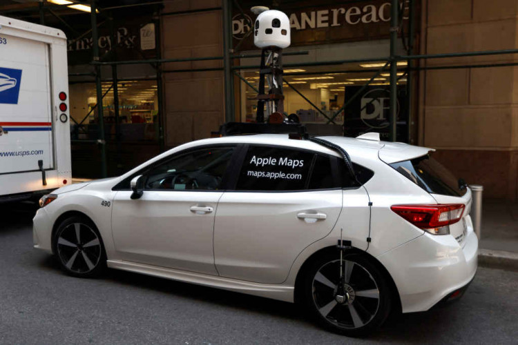
Apple started gathering data using modified vans but now, the Apple Maps teams also use a white Subaru Impreza, known within the company as "Ulysses." These vehicles, which come complete with advanced sensors and the EyeDrive system, belong to the 3D Vision team at Apple. They are in charge of combining numerous data with computer vision and state-of-the-art machine learning technologies to deliver 3D images on Apple Maps.
Ulysses features several hardware riggings, which include a conspicuous tower on the roof of the vehicle where advanced sensors, LiDAR scanners, high-resolution cameras, and Zeiss lenses are found. These hardware parts connect to a 2013 Mac Pro, which does all the work in processing all captured data in real-time. A modified iPad running the EyeDrive app and other riggings comprise the EyeDrive System, which is responsible for assigning the tasks and also allows members of the Apple Maps team to manage the data captured.
Aside from the advanced sensors, cameras, and EyeDrive system, the cars also have onboard four SSDs, each with a storage capacity of 4TB. While the storage space is huge, this is quickly filled up after only a week of data gathering. Apple depends on the overnight delivery service of UPS to immediately replace the SSDs.
Apple also has a self-driving Lexus codenamed "Tyche." The company uses them for Apple's autonomous driving efforts. All of the modified vehicles have their own version of the EyeDrive system and app, as well as onboard advanced sensors and other state-of-the-art technologies.
The modified vehicles, with their respective EyeDrive system and apps, advanced sensors, cameras, and all other riggings, are kept in a safe and unmarked location. Apple uses a front company that pays for the rent where the vehicles and all other rigging are stored. This is necessary to keep the real owner's identity a secret.
Usually, two members of the Apple Maps team operate the Ulysses units with one member driving, while the other manages the EyeDrive system and all other equipment, which include the advanced sensors and cameras. The duo receives precise instructions regarding the collection of data from senior members of the Apple Maps team.
The team begins collecting data in the morning when the position of the sun is at 30 degrees otherwise it might interfere with the vehicles' LiDAR sensors and other advanced sensors. They continue to drive and capture data until it reaches 30 degrees at night. Apple also requires that data gathering is conducted when weather conditions are good to ensure consistency in the quality of images. Each vehicle, including its EyeDrive system and other onboard technologies, are carefully inspected to ensure everything is properly working.
Once the teams are on the road, the EyeDrive system tells them their data gathering route. The operator periodically checks the images in real-time through the EyeDrive app on the iPad and confirm if the data looks okay or if there are any problems with the images, or the equipment, such as the advanced sensors and camera, used in capturing the data.
The EyeDrive system, with the help of its advanced sensors and other equipment, mark the vehicle's route with a green outline. The operator can check if a particular street is inaccessible either because it is under construction or belongs to a private area.
The teams turn off the EyeDrive system, advanced sensors, cameras, and all other equipment, at the end of each working day. Operators also make sure that all the captured data are safely stored. They then inspect the vehicles once more and also remove the SSDs and sent back to the headquarters. The captured data are primarily used to enrich Apple Maps features like Look Around and Flyover, where users can go on a sightseeing tour of 3D cities on the map. Oftentimes, you can see these advanced vehicles roaming the United States, though Apple is gradually expanding its data-gathering tasks to places like Japan, Canada, and Europe.